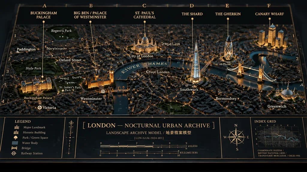
Cinematic physical museum-diorama map titled "[LONDON — NOCTURNAL URBAN ARCHIVE]", showing [London] at night as a raised 3D architectural archive model mounted on a flat printed cartographic board.
Composition and Camera: Wide horizontal 16:9 composition, three-quarter overhead view against a dark studio background, displayed in perspective like a premium museum archival planning exhibit.
Palette and Materials: Tactile matte blue-black paper surface with visible grain and beveled edges, navy water, charcoal city blocks, warm amber streetlights, muted gold linework, and subtle cool ambient highlights. Painted resin buildings casting realistic miniature shadows.
Diorama Details: The River Thames winds across the center labeled "RIVER THAMES". Exactly 7 prominent raised landmark clusters: Buckingham Palace with glowing frontage, Palace of Westminster and Big Ben beside the river, St. Paul’s Cathedral with a domed roof, The Shard as a glowing triangular glass tower, The Gherkin as a bullet-shaped tower, Tower Bridge crossing the river in warm light, and Canary Wharf as a cluster of tall golden-lit towers.
Annotations and Grid: Archival grid overlay with letters along the top and numbers along the sides, fine gold coordinate ticks, and a double-line border. Exactly 6 large top-edge labels with thin vertical leader lines: "BUCKINGHAM PALACE", "BIG BEN / PALACE OF WESTMINSTER", "ST. PAUL’S CATHEDRAL", "THE SHARD", "THE GHERKIN", and "CANARY WHARF". Exactly 14 smaller map place labels: Regent’s Park, Paddington, Marylebone, Oxford Street, Hyde Park, Green Park, St. James’s Park, Buckingham Palace, Victoria, Westminster, City of London, Southwark, Bermondsey, and Greenwich.
Bottom Information Band: Exactly 5 boxed panels across the bottom:
Panel 1: Legend with 6 icon rows (Major Landmark, Historic Building, Park / Green Space, Water Body, Bridge, Railway Station).
Panel 2: Narrow divider label strip.
Panel 3: Central title block showing "[LONDON — NOCTURNAL URBAN ARCHIVE]", subtitle "LANDSCAPE ARCHIVE MODEL / 地景檔案模型", archive code "[LDN-NAM-2024-001]", and dual scale bar in miles and kilometers.
Panel 4: Compass rose with N/E/S/W points.
Panel 5: "INDEX GRID" mini-map with text "COORDINATE SYSTEM / BRITISH NATIONAL GRID / TRANSVERSE MERCATOR / OSGB 1936".
Style: Photorealistic macro architectural photography, editorial lighting, crisp gold typography, no people, no street vehicles, no watermarks.
การทำแผนที่ไดโอรามาลอนดอน