
UI / UX डिज़ाइन
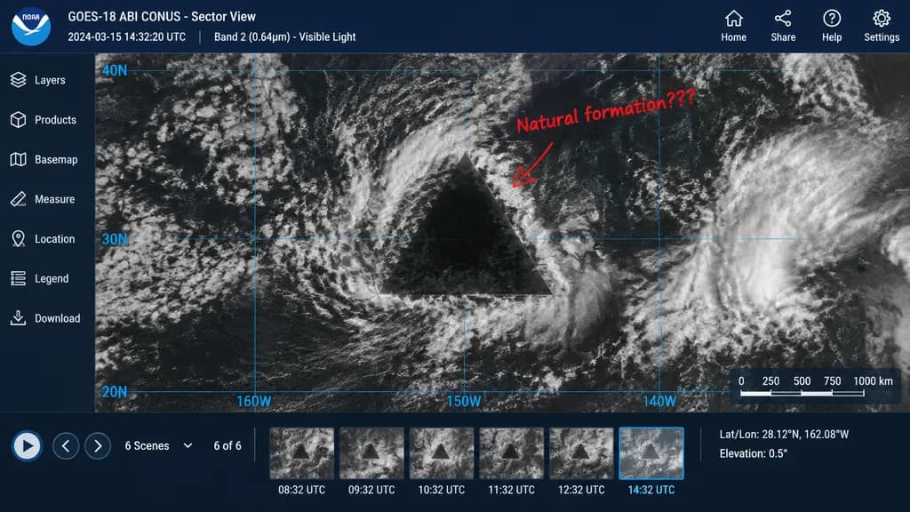
सैटेलाइट विसंगति वेब इंटरफ़ेस मॉकअप
समुद्री विसंगति दिखाने वाला एक यथार्थवादी उपग्रह व्यूअर यूआई बनाएं। अपनी कहानी के अनुसार विसंगति का आकार, हाथ से लिखे नोट्स या निर्देशांक बदलें।
सैटेलाइटइंटरफ़ेसयूआई-डिजाइनमॉकअपविसंगतिसाइंस-फिक्शनडैशबोर्ड
मिलते-जुलते प्रॉम्प्ट्स ब्राउज़ करेंयूज़र इंटरफ़ेस डिज़ाइन AI प्रॉम्प्ट्समॉकअप डिज़ाइन AI प्रॉम्प्ट्सविज्ञान कथा AI प्रॉम्प्ट्स
प्रॉम्प्ट
{
  "type": "satellite imagery web interface mockup",
  "main_display": {
    "imagery": "greyscale satellite view of ocean clouds featuring a [massive, perfectly geometric dark triangle] in the center",
    "annotation": "red handwritten text '[Natural formation???]' with a red arrow pointing to the anomaly",
    "overlay": "faint blue latitude and longitude grid lines with coordinate labels like 40N, 30N, 160W"
  },
  "ui_layout": {
    "top_header": {
      "left_section": "NOAA logo, text '[GOES-18 ABI CONUS - Sector View]', '[2024-03-15 14:32:20 UTC]', and 'Band 2 (0.64µm) - Visible Light'",
      "right_section": "4 navigation icons with labels: Home, Share, Help, Settings"
    },
    "left_sidebar": {
      "count": 7,
      "items": [
        "Layers",
        "Products",
        "Basemap",
        "Measure",
        "Location",
        "Legend",
        "Download"
      ]
    },
    "bottom_panel": {
      "timeline": {
        "controls": "Play button, left/right arrows, text '6 Scenes', '6 of 6'",
        "thumbnails": {
          "count": 6,
          "description": "sequential satellite images showing the anomaly's progression, with hourly timestamps from 08:32 UTC to 14:32 UTC"
        }
      },
      "data_readout": {
        "coordinates": "[Lat/Lon: 28.12°N, 162.08°W]",
        "elevation": "Elevation: 0.5°",
        "scale": "Distance Scale bar from 0 to 1000 km"
      }
    }
  }
}आप क्या बदल सकते हैं
इमेज बनाने से पहले प्रॉम्प्ट के इन हिस्सों को अपने विषय या शब्दों से बदलें।
[massive, perfectly geometric dark triangle]प्लेसहोल्डर[Natural formation???]प्लेसहोल्डर[GOES-18 ABI CONUS - Sector View]प्लेसहोल्डर
प्रॉम्प्ट का विवरण
- श्रेणी
- UI / UX डिज़ाइन
- मॉडल
- GPT IMAGE 2
- प्रति इमेज लागत
- 1K: 43 क्रेडिट · 2K: 86 क्रेडिट · 4K: 143 क्रेडिट
- आस्पेक्ट रेशियो
- 16:9
- जोड़ा गया