
Tez teknolojisi yol haritası
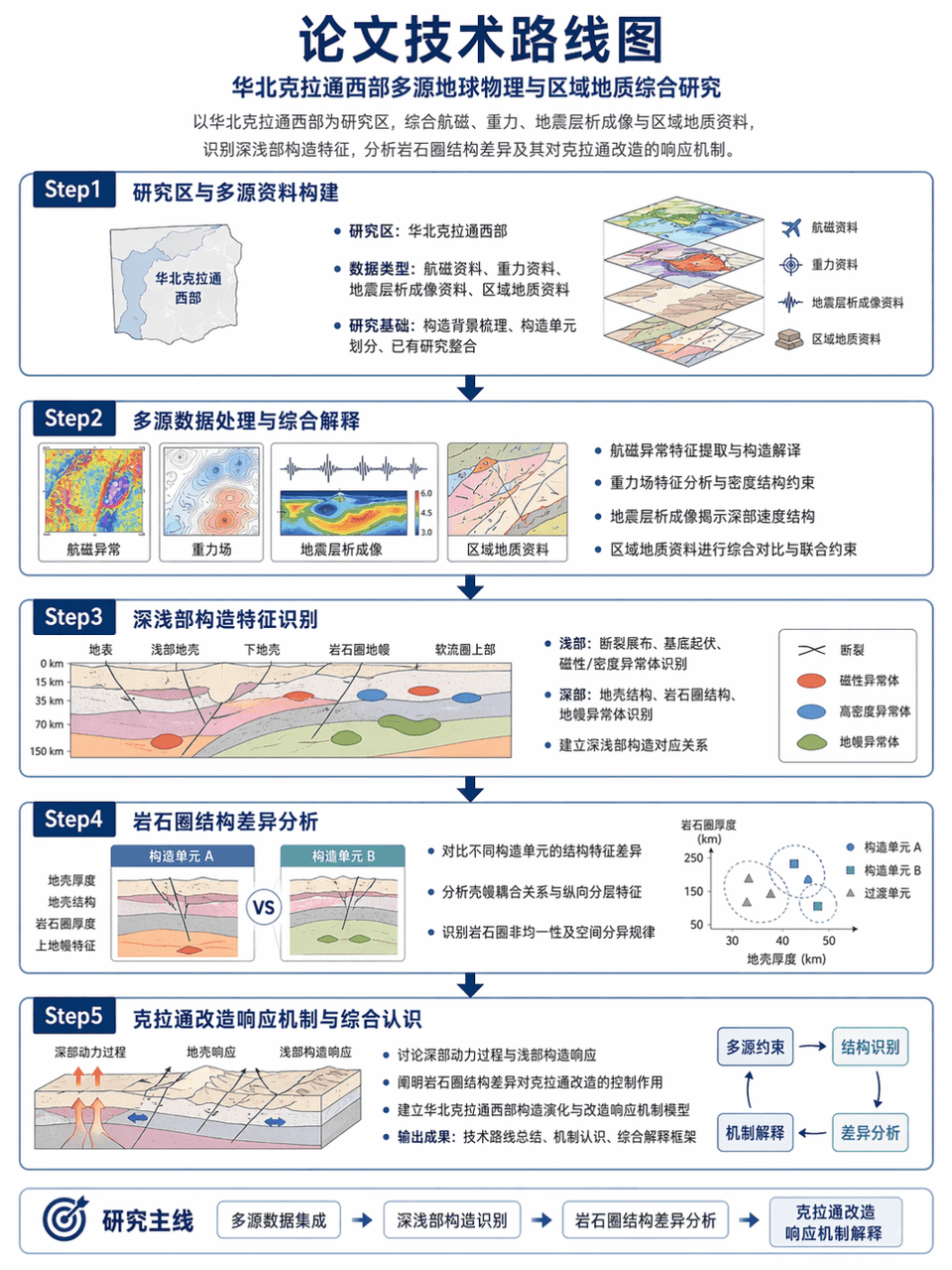
Resim çerçevesi 3:4, tezin teknik yol haritasını oluşturur: Kuzey Çin Kratonu'nun batı kısmını araştırma alanı olarak almak, havadan manyetik, yerçekimi, sismik tomografi ve bölgesel jeolojik verileri entegre etmek, der…
İstemi
Resim çerçevesi 3:4, tezin teknik yol haritasını oluşturur: Kuzey Çin Kratonu'nun batı kısmını araştırma alanı olarak almak, havadan manyetik, yerçekimi, sismik tomografi ve bölgesel jeolojik verileri entegre etmek, derin ve sığ yapısal özellikleri belirlemek ve litosferik yapıdaki farklılıkları ve kraton dönüşümüne tepki mekanizmasını analiz etmek. Açık oklar, doğru terminoloji ve ölçülü ve profesyonel düzen ile Adım1-Adım2-Adım3-Adım4-Adım5 yapısını kullanın.
Bu istem nasıl kullanılır?
Oluşturmadan önce Tez teknolojisi yol haritası isteminin tamamını okuyun ve konuyu, stili, kamerayı, ışıklandırmayı ve kompozisyon gereksinimlerini tanımlayın.
Parantezli veya bağımsız değişken tarzı yer tutucuları ürününüz, karakteriniz, markanız, sahneniz, renk paletiniz veya en boy oranı gereksinimlerinizle değiştirin.
https://www.gptimagehub.com/tr/generate?promptId=cmogxlpp500mhxt5gaxdstpre dosyasını açın, görüntüyü oluşturun, ardından gerekirse daha spesifik konu, metin, düzen veya negatif kısıtlamalarla istemi hassaslaştırın.
Bilgi İstemi SSS
Tez teknolojisi yol haritası istemi en iyi ne için kullanılır?
Bu istem, yeniden kullanılabilir bir yapı, ayrıntılı görsel yön ve tutarlı çıktı kalitesi istediğiniz diğer görselleri için en iyi şekilde kullanılır.
İstemi oluşturmadan önce düzenleyebilir miyim?
Evet. Bilgi istemi metninin tamamı bu sayfada görünür; böylece oluşturmadan önce konuları, ürün adlarını, renkleri, kompozisyonu, kamera terimlerini, en boy oranını ve stil notlarını değiştirebilirsiniz.
Bu istemle hangi modeli kullanmalıyım?
Bilgi istemi meta verilerinde gösterilen modeli varsayılan başlangıç noktası olarak kullanın. Başka bir görüntü modeli aynı en boy oranını ve talimat stilini destekliyorsa istemi uyarlayabilir ve sonuçları karşılaştırabilirsiniz.